Time Zones Explained: Why the World Isn't Divided Into 24 Clean Slices
Time zones divide the world into roughly 15-degree bands of longitude, each corresponding to about one hour of solar time difference, though real-world boundaries follow political borders rather than strict meridian lines.
Reading time
— 5 min
Updated
— Aug 16, 2026
Fact-reviewed
— Aug 16, 2026
Key Takeaways
Key Takeaways
1Time zones exist because Earth rotates 360° every 24 hours — 15° of longitude per hour — so places at different longitudes experience solar noon at genuinely different moments, and time zones standardize that into practical, agreed-upon hour blocks.
2Real time zone boundaries follow political and practical borders, not strict 15° meridian lines — some countries use offsets of 30 or 45 minutes, and a few span multiple time zones' worth of longitude but legally observe just one.
3UTC (Coordinated Universal Time), based on atomic clocks, is the modern reference standard every time zone is defined against — it replaced GMT for this technical role in 1972.
The concept
A time zone is a region that agrees to use the same clock time. Time zones exist because the sun is only directly overhead at one longitude at any given moment — when it's solar noon in London, it's already evening in Tokyo and still early morning in New York. Rather than every town keeping its own local sun-based time (which used to genuinely happen), countries grouped into wide bands that all share one standard clock time, roughly matching the general time of day the sun suggests for that region.
The 15°-per-hour math explains the theory cleanly — but real time zone maps look far messier than that theory predicts, and the reasons why are entirely political, not astronomical.
Quick check
China spans roughly five time zones' worth of longitude but legally observes only one, UTC+8, nationwide. What's the main real-world consequence of this?
Worked examples
Example 1: Estimating a theoretical time zone from longitude (baseline case)
A location sits at 90°W longitude. Dividing by 15 (the degrees of longitude per hour): 90 ÷ 15 = 6 hours behind the Prime Meridian, or roughly UTC-6. This lines up closely with the real-world Central Time Zone in the United States, which uses UTC-6 standard time — a case where the theoretical, purely longitude-based calculation and the real political time zone happen to match closely, since the U.S. central time zone boundaries were drawn reasonably close to their 'natural' meridian lines.
Example 2: The International Date Line's political zigzag (edge case / variation)
The International Date Line roughly follows the 180° meridian — the theoretical opposite side of the globe from the Prime Meridian, where crossing it means the calendar date changes by a full day. But it isn't a straight line: it zigzags around island nations so that a country isn't split across two different calendar dates. Kiribati moved its portion of the line eastward in 1995 specifically so the entire country could share one date rather than being split in two, and in 2011 Samoa jumped from UTC-11 to UTC+13 (skipping December 30 entirely that year) largely to align its business week with major trading partners Australia and New Zealand rather than the United States. Both changes were driven entirely by economic and political convenience, not any astronomical necessity.
Quick check
Why does the International Date Line zigzag instead of following the 180° meridian in a perfectly straight line?
Example 3: Why some countries use 30- or 45-minute offsets (real-world / applied case)
India, a large country spanning nearly 30° of longitude, adopted a single time zone at UTC+5:30 after independence — a half-hour offset chosen specifically to sit at a reasonable compromise between the country's eastern and western longitude extremes rather than picking either a whole-hour zone that would favor one region over the other, or splitting the country into multiple official zones. Nepal goes a step further, using UTC+5:45, positioned to align its official time more precisely with the longitude running through Kathmandu. These aren't errors or oddities in the system — they're deliberate national decisions weighing precise solar alignment against the practical convenience of a single, simple national time.
How it works (visual)
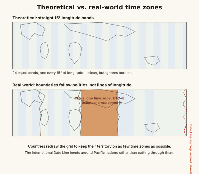
Theoretical 15° time zones vs. real-world political boundaries
The contrast between the two maps is the whole story: the theoretical grid is astronomy, and the real map is politics layered on top of that astronomy, sometimes bending it dramatically for a single country's convenience.
Common mistakes
Common Mistakes
✕
Assuming every time zone is exactly one hour apart from its neighbor.
→ Check for the handful of 30- or 45-minute offset zones (India, Nepal, and several others) — not every boundary is a clean whole-hour step.
✕
Assuming time zone borders follow straight lines of longitude.
→ Remember real-world boundaries bend around political borders — a time zone map looks far messier than the clean 15° theoretical grid it's loosely based on.
✕
Confusing GMT and UTC as if they're identical in every technical sense.
→ Treat UTC as the modern atomic-clock-based standard since 1972; GMT is closely related and often used interchangeably in casual speech, but UTC is the precise technical reference now.
Common misconception
“Time zones are always exactly one hour apart and follow strict lines of longitude.”
Real time zones diverge substantially from the clean 15°-wide theoretical grid. Several countries use 30- or 45-minute offsets rather than whole hours — India (UTC+5:30) and Nepal (UTC+5:45) among them. Political borders routinely override longitude entirely: China spans roughly five time zones' worth of longitude but uses one single official time zone nationwide, while the International Date Line zigzags around Pacific island nations rather than following the 180° meridian in a straight line. The 15°-per-hour math is the starting theory, not the final real-world map.
Quick check
India uses a single national time zone of UTC+5:30 rather than a whole-hour offset. What does this best illustrate about real-world time zones?
Try it yourself
Estimate a theoretical time zone offset from longitude
Estimated UTC offset (hours)-6
What to do next
What to do next
Try the calculator above with your own longitude to see how close your region's real time zone sits to the pure theoretical estimate.
Next time you plan an international call or trip, double-check whether the destination uses a 30- or 45-minute offset before assuming a clean whole-hour difference.
Look up whether your country or region observes Daylight Saving Time, and if so, when the next clock shift happens.
Read the related entry on Latitude & Longitude Explained to see exactly how longitude sets the theoretical basis for every time zone.
FAQ
FAQ
Related terms
Related terms
Time zone
A region of Earth that observes a uniform standard time, typically offset from UTC by a whole or half/quarter hour.
UTC (Coordinated Universal Time)
The primary global time standard, based on atomic clocks, from which all time zones are measured as an offset (e.g. UTC+5, UTC-8).
International Date Line
An imaginary line roughly following the 180° meridian in the Pacific Ocean, where the calendar date changes by one day when crossed, zigzagging to avoid splitting some countries.
Daylight Saving Time
The practice of shifting clocks forward (typically by one hour) during part of the year to extend evening daylight, observed by some but not all countries.
Solar time
Time measured directly by the position of the sun, where solar noon is when the sun is at its highest point — the original basis for time before standardized zones existed.
 KnowThis