 KnowThis
Key Takeaways
Key Takeaways
- 1Ocean currents are driven mainly by wind at the surface and by density differences from temperature and salinity in the deep ocean — not by tides, which are a separate, gravity-driven phenomenon.
- 2The Gulf Stream moves an enormous volume of warm water northward — more than all the world's rivers combined — and is a major reason Western Europe is milder than other places at the same latitude, like Labrador, Canada.
- 3Currents don't just move water, they move heat: this redistribution is a core driver of Earth's climate system, and disruptions to it (like El Niño) shift weather patterns across the entire globe.
The concept
Wind and density explain why currents move — the more useful question for a reader is what that movement actually does once it's underway, both for a drifting object and for the climate of an entire coastline.
What is the main force that drives most ocean currents?
Worked examples
Example 1: How fast is the Gulf Stream, and how far does it carry water in a day? (baseline case)
Example 2: The global conveyor belt — a current that takes 1,000 years to complete one loop (edge case / variation)
The Gulf Stream moves water at several km/h, but the deep thermohaline 'conveyor belt' can take about 1,000 years to complete one loop. How can both be called 'ocean currents'?
Example 3: How the Gulf Stream keeps Western Europe milder than expected (real-world / applied case)
London sits at roughly the same latitude as parts of Labrador, Canada — a region with long, brutally cold winters — yet London's winters are far milder. The difference comes down to ocean currents: the Gulf Stream carries warm water from the Gulf of Mexico across the Atlantic, where it becomes the North Atlantic Drift and releases heat into the air as it passes near Western Europe's coastline. That heat gets carried further inland by prevailing westerly winds, moderating temperatures across the UK, France, and parts of Scandinavia relative to other locations at the same latitude that don't sit downstream of a warm current. This is a direct, observable consequence of current-driven heat redistribution, not a coincidence of geography alone.
How it works (visual)
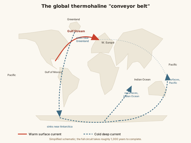
Follow the red arrow from the Gulf of Mexico: it traces the Gulf Stream's warm path up the U.S. coast and across to Europe. Near Greenland, that warm water cools, gets saltier as sea ice forms, and sinks — shown as the point where the arrow turns blue and dives toward the seafloor. From there it creeps southward at depth for centuries before eventually resurfacing near the Pacific, completing the loop. The entire system functions as one connected loop, not separate currents in each ocean.
Common mistakes
Common Mistakes
Confusing ocean currents with tides, or assuming they're driven by the same force.
→ Tides are driven by the gravitational pull of the Moon and Sun and cause water levels to rise and fall on a predictable daily cycle. Currents are driven by wind and water density and cause water to flow horizontally in a consistent direction — different mechanisms entirely.
Assuming all ocean currents move at roughly the same speed.
→ Surface currents like the Gulf Stream can move several km/h; deep thermohaline currents move on the scale of centimeters per second and can take centuries to complete a single loop.
Thinking currents only matter locally, near the coastline where they're most visible.
→ Currents redistribute heat on a planetary scale — the Gulf Stream alone measurably changes the climate of an entire region (Western Europe) thousands of kilometers from where the current originates.
Common misconception
“Ocean currents are caused mainly by the same forces that cause tides.”
Tides and currents are driven by entirely different mechanisms. Tides come from the gravitational pull of the Moon (and, to a lesser extent, the Sun) on Earth's oceans, producing a predictable rise and fall of sea level roughly twice a day at most coastlines. Ocean currents, by contrast, are driven mainly by wind dragging on the surface and by density differences from temperature and salinity in the deep ocean — gravity from the Moon plays essentially no role in generating them. A location can have strong currents and weak tides, or the reverse; the two systems operate independently, even though both involve moving seawater.
A coastal town has very strong tides but relatively weak local ocean currents. Is this contradictory?
Try it yourself
What to do next
What to do next
- Try the calculator above with the Gulf Stream's top speed (about 9 km/h) over a shorter distance, like 500 km, to see how quickly a fast surface current covers ground.
- Next time you check a weather forecast mentioning El Niño or La Niña, connect it back to shifting surface currents and temperatures in the tropical Pacific.
- Compare London's average winter temperature to a city at a similar latitude on the eastern side of a continent (like Labrador or Newfoundland) to see the Gulf Stream's effect for yourself.
- Read the related entry on The Five Oceans Explained to see the full ocean basins these currents flow through.