Islands & Archipelagos: How Land Ends Up Surrounded by Water
An island is any landmass smaller than a continent surrounded by water, formed by one of four mechanisms: continental separation, volcanic activity, coral reef growth, or sediment deposition.
Reading time
— 5 min
Updated
— Aug 16, 2026
Fact-reviewed
— Aug 16, 2026
Key Takeaways
Key Takeaways
1Islands form through at least four distinct mechanisms — continental separation, volcanic activity, coral reef growth, and sediment deposition — not a single universal process.
2The Hawaiian Islands form a textbook 'hotspot chain': a stationary plume of rising magma stays fixed while the Pacific Plate slides slowly over it, building a line of volcanoes that gets progressively older moving away from the active one.
3An atoll isn't a separate kind of island from a volcanic one — it's what a volcanic island becomes after millions of years, once the volcano sinks beneath the waves and only its coral reef rim remains above water.
The concept
An island is simply any piece of land, smaller than a continent, that's completely surrounded by water. An archipelago is a group or chain of islands — Indonesia, with more than 17,000 islands, and Hawaii, with its main chain of eight, are both archipelagos, even though they formed in totally different ways. Islands aren't all built the same way: some are broken-off pieces of continents, some are volcanoes poking above the ocean surface, and some are built almost entirely out of coral.
Knowing there are multiple formation types explains why islands look so different from each other — and nowhere is that difference more visible, or more precisely measurable, than in a single hotspot-built island chain.
Quick check
Indonesia has more than 17,000 islands and Hawaii has 8 main islands, yet both are called 'archipelagos.' What does the term actually require?
Worked examples
Example 1: The Hawaiian hotspot chain (baseline case)
The Big Island of Hawaii sits directly above the Hawaiian hotspot today and is still actively erupting. Moving northwest along the island chain — Maui, Oahu, Kauai — each island is progressively older, because the Pacific Plate has been sliding slowly northwest over the roughly stationary hotspot for millions of years, leaving a trail of extinct volcanoes behind it like a conveyor belt passing over a fixed torch. Kauai, the oldest of the main islands, is roughly 5 million years old and has eroded into the deep, jagged valleys the island is known for, while the Big Island's youngest slopes are still bare, fresh lava rock.
Example 2: The Emperor Seamounts, a hotspot chain's hidden older half (edge case / variation)
The Hawaiian chain doesn't stop at Kauai — it continues underwater as the Emperor Seamounts, a chain of now-submerged volcanoes stretching all the way to the edge of the Aleutian Trench near Alaska, with the oldest seamounts dated at roughly 80 million years. There's a sharp bend in the chain where the Hawaiian Islands meet the Emperor Seamounts, dated to roughly 47 million years ago — evidence that the direction of Pacific Plate motion itself changed at that point in Earth's history, a shift the hotspot chain recorded like a geological odometer even though no one was there to observe it happening.
Quick check
Why does the Hawaiian-Emperor seamount chain have a sharp bend in it partway along its length?
Example 3: How an atoll forms from a sinking volcano (real-world / applied case)
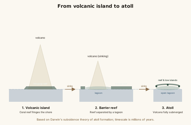
A newly formed volcanic island first grows a fringing coral reef directly against its shoreline. As the volcanic rock slowly subsides — cooling, contracting, and sinking under its own weight over millions of years — the coral keeps growing upward toward sunlight faster than the island sinks, so the reef ends up separated from the shrinking island by a lagoon, forming a barrier reef. Eventually the volcano disappears entirely beneath the surface, leaving only a ring of coral reef and low coral-sand islands surrounding an open lagoon: an atoll. The Maldives and much of Kiribati and the Marshall Islands are built almost entirely from this end-stage of volcanic islands that finished sinking long ago, which is also why these low-lying atoll nations are especially vulnerable to even small amounts of sea-level rise.
How it works (visual)
From volcanic island to atoll: three stages of subsidence
The same island works its way through all three stages over millions of years — the reef doesn't "replace" the volcano so much as outlast it, continuing to grow upward toward sunlight long after the rock underneath has sunk out of sight.
Common mistakes
Common Mistakes
✕
Assuming all islands form from volcanoes.
→ Check which of the four mechanisms applies — continental separation, volcanic activity, coral reef growth, or sediment deposition — since many of the world's largest islands (Greenland, Madagascar) are continental fragments, not volcanoes.
✕
Treating atolls as a totally separate category from volcanic islands.
→ Remember an atoll is usually the final stage of a volcanic island's life cycle, after the volcanic rock has fully subsided beneath the coral reef that grew around it.
✕
Assuming a hotspot itself moves to create an island chain.
→ The hotspot is understood to stay roughly fixed; it's the tectonic plate sliding over it that creates the chain, with the youngest island always sitting directly above the currently active hotspot.
Common misconception
“All islands were formed by volcanic eruptions.”
Volcanic activity built plenty of islands, including all of Hawaii and Iceland, but it's only one of at least four distinct formation mechanisms. Greenland and Madagascar are continental islands — pieces of ordinary continental crust that separated from a larger landmass, geologically no different from the mainland they came from. Barrier islands like the Outer Banks are built from sand deposited by waves and currents, with no volcanic origin at all. And atolls, while they do start as volcanoes, are what's left long after the volcanic rock has disappeared beneath a coral reef.
Quick check
Greenland, the world's largest island, has no active volcanoes and isn't a coral atoll. How did it form?
Try it yourself
Estimate a hotspot island's age from its distance and plate speed
Estimated island age (millions of years)7.14
What to do next
What to do next
Try the calculator above with Kauai's roughly 500km distance from the Big Island and the Pacific Plate's roughly 7cm/year speed to see if the estimated age lands near the real figure of about 5 million years.
Next time you look at a map of an island nation, guess its formation type first — continental fragment, volcanic, atoll, or barrier island — before checking.
Look up whether the island closest to you (or one you're curious about) sits on a hotspot chain, a mid-ocean ridge, or is a continental fragment.
Read the related entry on Volcanoes Around the World to go deeper on the plate-tectonic mechanisms behind hotspot and ridge volcanism.
FAQ
FAQ
Related terms
Related terms
Island
A landmass smaller than a continent that is entirely surrounded by water.
Archipelago
A group or chain of islands, often formed by a shared geological process such as a volcanic hotspot or mid-ocean ridge.
Continental island
An island formed from a detached piece of continental crust, geologically part of a nearby continent rather than built up from the ocean floor.
Hotspot
A relatively fixed source of upwelling magma in the mantle that stays in place while a tectonic plate moves slowly over it, producing a chain of volcanic islands.
Atoll
A ring-shaped coral reef and island surrounding a central lagoon, formed as a coral reef around a volcanic island continues growing upward while the volcano itself slowly sinks.
Barrier island
A long, narrow island made of sand and sediment, running parallel to a coastline and built up by wave and current action rather than volcanic or coral processes.
 KnowThis