Deserts of the World: Why They Form and Why Most Aren't Hot
A desert is any region that receives less than about 250mm of precipitation a year, regardless of temperature — which is why the Sahara, the Gobi, and Antarctica all qualify.
Reading time
— 5 min
Updated
— Aug 16, 2026
Fact-reviewed
— Aug 16, 2026
Key Takeaways
Key Takeaways
1A desert is defined by precipitation, not temperature — any region averaging under about 250mm of rain or snow a year qualifies, which means Antarctica is technically the largest desert on Earth.
2Deserts form through four distinct mechanisms: subtropical high-pressure belts, mountain rain shadows, distance from any moisture source, and cold coastal ocean currents.
3The Sahara, at roughly 9.2 million km², is the largest hot desert, but Antarctica's roughly 14 million km² of polar desert makes it larger still by area.
The concept
A desert is any place that stays extremely dry year-round — not necessarily a place that's hot. The Sahara is a desert because it barely rains there, not because it's scorching; Antarctica is also a desert, by the exact same standard, because it barely snows there either, even though it's buried under ice that has piled up over hundreds of thousands of years. What all deserts share is a lack of moisture, not a particular temperature.
That precipitation-based definition is the whole ballgame here, and it produces results that feel wrong until you check the actual numbers — starting with which desert is really the biggest.
Quick check
Which is technically the largest desert on Earth by total area?
Worked examples
Example 1: The Sahara as a subtropical-high desert (baseline case)
The Sahara sits almost entirely between roughly 15°N and 30°N, squarely under the descending arm of the Hadley cell. Air that rose over the equator, dumped its moisture as tropical rain, and cooled at high altitude sinks back down here — and sinking air compresses and warms, which pulls it further from saturation rather than closer, so it produces almost no rain at all. This is the textbook mechanism behind most of the world's hottest, driest deserts: the Sahara, the Arabian Desert, the Kalahari, and the Australian Outback all sit in this same latitude band on different continents, which is itself strong evidence the cause is atmospheric circulation and not some local coincidence repeated four separate times.
Example 2: Antarctica as a polar desert (edge case)
Antarctica's interior receives well under 250mm of precipitation a year — in some inland regions, under 50mm, comparable to parts of the Sahara. Extremely cold air simply cannot hold much water vapor (warmer air holds far more moisture than cold air), so very little snow ever actually falls; the ice sheet covering the continent up to nearly 4.8km thick is the product of that meager annual snowfall barely melting or evaporating and instead compacting for hundreds of thousands of years. It looks nothing like a sand dune, but by the actual precipitation-based definition used by geographers, Antarctica is unambiguously a desert — the driest and largest one on the planet.
Quick check
Antarctica is covered in ice up to nearly 4.8km thick, yet it's classified as a desert. How can both be true?
Example 3: The Atacama Desert and real-world water engineering (real-world / applied case)
Chile's Atacama Desert sits in a rain shadow of the Andes and above the cold, offshore Humboldt Current, stacking two dry-climate mechanisms on top of each other. Because rainfall is so unreliable, some Atacama communities rely on fog-catching nets — mesh panels strung on hillsides that intercept moisture from coastal fog and let it condense and drip into collection troughs, supplying water for small towns where conventional rainfall can't be counted on at all. It's a direct engineering response to the same physical mechanism that makes the region so dry in the first place: reliable coastal fog instead of reliable rain.
How it works (visual)
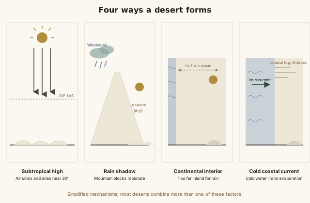
Four ways a desert forms: subtropical high, rain shadow, continental interior, cold coastal current
All four mechanisms produce the same outcome — persistent low precipitation — through completely different physical causes, which is why deserts show up on every continent except Antarctica's ice-free coastal margins in wildly different climates and latitudes rather than clustering in one obvious pattern.
Common mistakes
Common Mistakes
✕
Assuming 'desert' means 'hot and sandy.'
→ Reclassify desert by its real definition — low precipitation. Cold deserts (Antarctica, the Gobi) and rocky, non-sandy deserts are just as legitimately deserts as the Sahara.
✕
Assuming all deserts form the same way.
→ Check which of the four mechanisms applies — subtropical high, rain shadow, continental interior, or cold coastal current — since the cause changes what the region's climate and geology actually look like.
✕
Thinking deserts never get rain at all.
→ Most deserts do get occasional rain — sometimes in sudden, intense bursts — the defining trait is a low long-term average, not literally zero precipitation ever.
Common misconception
“All deserts are hot.”
Desert classification is based on precipitation, not temperature. Antarctica, the coldest continent on Earth, is also its largest desert by area — its interior receives less annual precipitation than large parts of the Sahara. The Gobi Desert in Mongolia has brutally cold winters, often well below freezing, and is still unambiguously classified as a desert. "Hot and dry" describes only one of several distinct desert types.
Quick check
Why does Antarctica count as a desert even though it's the coldest place on Earth?
Try it yourself
What share of Earth's total land area does a region cover?
Share of Earth's total land area (%)6.18
What to do next
What to do next
Try the calculator above with Antarctica's roughly 14,000,000 km² to see how much larger it is, by area, than the Sahara.
Next time you hear 'desert,' picture the precipitation definition first — hot and sandy is only one of at least four distinct desert types.
Look up which of the four formation mechanisms explains the desert closest to you, or the one you're most curious about.
Read the related entry on Climate Zones Explained to see how deserts fit into the broader Koppen classification system.
FAQ
FAQ
Related terms
Related terms
Desert
A region that receives less than roughly 250mm (about 10 inches) of precipitation per year, classified by dryness rather than temperature.
Subtropical high
A belt of descending, warming, moisture-shedding air found around 30° north and south latitude, formed by the Hadley cell — the source of most of the world's hot deserts.
Rain shadow
A dry region on the leeward (downwind) side of a mountain range, where moist air has already dropped most of its rain on the windward side.
Cold desert
A desert defined by low precipitation rather than high temperature, including polar deserts like Antarctica and mid-latitude deserts like the Gobi.
Hadley cell
A large-scale atmospheric circulation pattern in which warm, moist air rises near the equator and descends as dry air around 30° latitude.
Endorheic basin
A drainage basin with no outlet to the ocean, where water collects and evaporates rather than flowing out — common in continental interior deserts.
 KnowThis