Earth's geographic superlatives — highest point, deepest trench, longest river, largest desert — each trace back to a specific tectonic or climatic cause, and several of the most famous 'records' depend heavily on how exactly they're measured.
Reading time
— 5 min
Updated
— Aug 16, 2026
Fact-reviewed
— Aug 16, 2026
Key Takeaways
Key Takeaways
1Every geographic superlative traces back to a specific cause — Mount Everest's height comes from ongoing tectonic collision, the Mariana Trench's depth comes from a subduction zone, and the Sahara's size comes from a persistent global wind pattern, not just 'hot weather.'
2Mount Everest is the highest point above sea level, not necessarily the 'tallest mountain' — measured base-to-summit from the ocean floor, Hawaii's Mauna Kea is actually taller.
3Even a seemingly simple record like 'the world's longest river' is genuinely disputed between the Nile and the Amazon, because the answer depends on exactly where a river is defined to begin.
The concept
A geographic superlative is a record-holding extreme: the highest point (Mount Everest), the deepest ocean point (the Mariana Trench's Challenger Deep), the lowest point on land (the Dead Sea shore), the largest desert, the coldest and hottest recorded temperatures. Each one exists because of a specific, identifiable cause in Earth's geology or climate — none of these records are arbitrary, and most of them connect back to the same handful of processes covered elsewhere on this site: plate tectonics, erosion, and global wind and pressure patterns.
That same "check the definition before trusting the record" caution applies just as strongly to the world's most commonly cited mountain superlative — which, it turns out, depends entirely on what exactly is being measured.
Quick check
Mount Everest is almost always described as the world's tallest mountain. What's the more precise way to describe its record?
Worked examples
Example 1: Mount Everest's height and ongoing uplift (baseline case)
Mount Everest's most recent officially recognized height, from a joint China-Nepal survey completed in 2020, is 8,849 meters (29,032 feet) above sea level. The mountain continues to rise a few millimeters per year as the Indian Plate keeps pushing into the Eurasian Plate — a collision that has been ongoing for roughly 50 million years. Erosion works against this uplift constantly, wearing the peak down, but tectonic uplift in the Himalayas has outpaced erosion for millions of years, which is why the range keeps growing overall rather than leveling out.
Example 2: The Nile vs. Amazon "longest river" debate (edge case / variation)
For over a century, the Nile (roughly 6,650 kilometers) was the textbook answer to "world's longest river," edging out the Amazon (commonly cited around 6,400 kilometers). But the exact figures depend heavily on where each river's source is defined to begin — a genuinely contested scientific question, since a river's most distant headwater stream isn't always obvious or agreed upon. Some more recent studies, using different source-point definitions for the Amazon's most remote tributary, have put the Amazon's length ahead of the Nile's. Encyclopaedia Britannica and other major references still note this as an active, unresolved measurement debate rather than a settled fact — a rare case where a "simple" superlative turns out to hinge entirely on methodology.
Quick check
Why is there still genuine scientific debate over whether the Nile or the Amazon is the world's longest river?
Example 3: How many Everests deep is the Mariana Trench? (real-world / applied case)
The Mariana Trench's Challenger Deep reaches roughly 10,935 meters below the ocean surface — deeper than Mount Everest (8,849 meters) is tall. Dividing trench depth by Everest's height (10,935 ÷ 8,849) gives a ratio of about 1.24, meaning if Everest were dropped into the Challenger Deep, its summit would still sit more than 2,000 meters below the ocean surface. This kind of direct comparison is also how NOAA and other agencies communicate the trench's scale to the public, since a raw number like "10,935 meters" is much harder to intuitively grasp than "deeper than Everest is tall, with over 2,000 meters to spare."
How it works (visual)
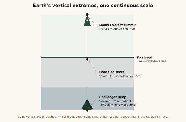
Earth's vertical extremes on one scale: Everest, sea level, the Dead Sea, and the Mariana Trench
Placed on one continuous vertical axis with sea level as the zero point, the true scale becomes clear: the distance from Everest's summit down to the Challenger Deep spans nearly 19,800 meters — almost 20 kilometers of vertical relief on a single planet, all measured against the same fixed sea level datum that every one of these records depends on.
Common mistakes
Common Mistakes
✕
Assuming Mount Everest is the 'tallest mountain' in every possible sense.
→ Everest is the highest point above sea level. Measured base-to-summit from the ocean floor, Hawaii's Mauna Kea is actually taller overall.
✕
Assuming the Sahara is unambiguously the world's largest desert.
→ By the standard climate definition (low precipitation, not heat), Antarctica is actually the largest desert on Earth by total area.
✕
Treating 'world's longest river' as a permanently settled fact rather than a genuinely contested measurement.
→ The Nile-vs-Amazon ranking depends on where each river's headwater source is defined to begin — a real, ongoing scientific debate, not settled trivia.
Common misconception
“Mount Everest is the tallest mountain in the world.”
Everest holds the record for highest point above sea level (8,849 meters) — but "tallest mountain," measured base-to-summit, is a different question. Hawaii's Mauna Kea rises only about 4,207 meters above sea level, far short of Everest, but its base sits on the Pacific Ocean floor roughly 6,000 meters below the surface. Measured from that true base to its summit, Mauna Kea's total height is around 10,210 meters — taller than Everest overall, even though most of that height is hidden underwater. Both records are real; they're just answering slightly different questions about what "tallest" means.
Quick check
If Mount Everest is the highest point above sea level, why is Hawaii's Mauna Kea sometimes described as the 'tallest mountain' instead?
Try it yourself
How many 'unit heights' stack to match a superlative's height or depth
Number of stacked units to match that height/depth1.24
What to do next
What to do next
Try the calculator above comparing the Dead Sea's depth below sea level (about 430m) to a familiar building or landmark height near you.
Next time you see a 'world's longest river' claim stated as settled fact, check which source-point definition it's using — the Nile-vs-Amazon question genuinely isn't fully resolved.
Look up your own country or region's highest and lowest points, and check whether they connect to a rift valley, a mountain range, or another tectonic feature covered here.
Read the related entry on Mountains and Mountain Ranges to go deeper on the tectonic uplift process behind Everest and other major peaks.
FAQ
FAQ
Related terms
Related terms
Geographic superlative
A record-holding extreme measurement of a natural feature — the highest, lowest, longest, deepest, hottest, or coldest point on Earth.
Rift valley
A long depression in Earth's surface formed where tectonic plates are pulling apart, often creating below-sea-level basins like the Dead Sea's.
Subduction zone
A boundary where one tectonic plate is forced beneath another, a process that creates deep ocean trenches like the Mariana Trench.
Prevailing wind belt
A large-scale, persistent global wind pattern (such as the subtropical high-pressure belts near 30° latitude) that strongly influences where the world's great deserts form.
Sea level datum
The standardized reference point ('zero elevation') that all height and depth measurements on Earth, including record-holding superlatives, are measured against.
 KnowThis