GPS calculates your position by measuring how long radio signals take to arrive from at least four satellites and using those precise time differences to trilaterate an exact location on Earth.
Reading time
— 5 min
Updated
— Aug 16, 2026
Fact-reviewed
— Aug 16, 2026
Key Takeaways
Key Takeaways
1GPS works by trilateration, not triangulation — receivers measure the precise travel time of radio signals from at least four satellites and use those distances, not angles, to calculate an exact position.
2GPS satellites orbit at roughly 20,200km altitude and carry atomic clocks accurate enough to lose only about one second every 100 million years, because even a tiny clock error translates into a large position error.
3Light (and radio signals) travels roughly 30cm per nanosecond, which is why GPS satellite clocks must be corrected for relativistic effects — without correction, timing errors would accumulate into several kilometers of position error per day.
The concept
GPS works by listening to signals from satellites orbiting far above Earth, not by talking to cell towers. Each satellite constantly broadcasts the exact time the signal was sent. Your phone or GPS receiver picks up signals from several satellites at once, measures how long each one took to arrive, and uses those tiny time differences — since radio signals travel at the speed of light — to calculate exactly how far away each satellite is. With distances to at least four satellites known, your receiver can pinpoint your location on Earth to within a few meters.
That last detail — a receiver needing a fourth satellite just to fix its own imperfect clock — is the key to understanding why GPS timing precision matters so much more than it might seem at first.
Quick check
Why does a GPS receiver typically need signals from at least four satellites, not just three?
Worked examples
Example 1: How long a GPS signal takes to reach the ground (baseline case)
A GPS satellite orbits at roughly 20,200km altitude. Radio signals, like all electromagnetic waves, travel at the speed of light: roughly 299,792km per second. Travel time = distance ÷ speed = 20,200 ÷ 299,792 ≈ 0.0674 seconds, or about 67 milliseconds. That's the baseline delay between a satellite sending its time-stamped signal and a receiver on the ground picking it up — a delay so brief it's imperceptible to a person, but large enough, at the speed light travels, to require atomic-clock precision to measure usefully for positioning.
Example 2: Why a tiny clock error causes a large position error (edge case / variation)
Because radio signals travel at the speed of light, even a minuscule timing error translates directly into a real distance error — light travels roughly 30cm in a single nanosecond (one billionth of a second). A clock error of just 1 microsecond (1,000 nanoseconds) therefore corresponds to a position error of roughly 300 meters, and the uncorrected 38-microsecond-per-day relativistic drift mentioned earlier would, left unfixed, produce roughly 10km of error per day — utterly useless for navigation. This is precisely why GPS satellite clocks are engineered atomic clocks rather than ordinary quartz clocks, and why their onboard time is deliberately adjusted to run slightly slower before launch, to compensate in advance for the relativistic speed-up they'll experience once in orbit.
Quick check
A GPS satellite's clock drifts by just 1 microsecond of uncorrected error. Roughly how much position error does that translate to?
Example 3: GPS beyond phones — how the technology gets used (real-world / applied case)
Beyond turn-by-turn directions on a phone, the same underlying trilateration technique synchronizes financial trading systems and power grid timing (both of which depend on GPS's atomic-clock-derived time signal, not just its positioning function), guides precision agriculture equipment to within centimeters for automated planting and harvesting, and powers emergency services' ability to locate a 911 caller's phone. Because all of this infrastructure depends on the same satellite signals, GPS outages or jamming — whether from solar storms disrupting signals or deliberate interference — have real, non-navigation consequences, which is a major reason why several countries maintain independent regional or global satellite navigation systems (Europe's Galileo, Russia's GLONASS, China's BeiDou) rather than relying on U.S.-operated GPS alone.
How it works (visual)
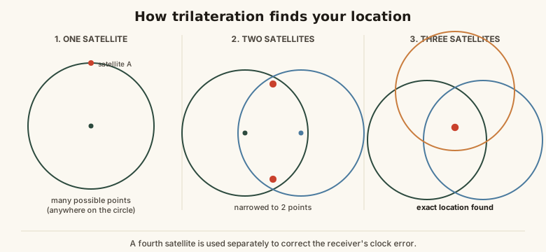
Trilateration: how overlapping satellite distances narrow down one exact location
Each satellite doesn't point a beam at you or otherwise know where you are — it just broadcasts a precise timestamp outward in every direction, and all of the actual position-solving happens inside your own receiver, comparing timestamps and computing overlapping distance spheres.
Common mistakes
Common Mistakes
✕
Assuming GPS works by triangulating signals from cell phone towers.
→ Separate the two technologies: GPS uses satellite-based trilateration (distance measurements), while cell tower location is a completely different, less precise technique sometimes used as a GPS backup indoors.
✕
Thinking GPS satellites actively track or 'see' your phone's location.
→ Remember the signal only flows one way, satellite to receiver — satellites broadcast timestamps outward with no knowledge of who's listening, and your device does all the position calculation locally.
✕
Assuming a tiny clock error is negligible for GPS accuracy.
→ Scale it up: because signals travel at the speed of light, even a 1-microsecond clock error becomes roughly 300 meters of position error — which is why atomic-clock precision genuinely matters here.
Common misconception
“GPS works by triangulating signals from nearby cell phone towers.”
GPS is a satellite-based system that has nothing fundamentally to do with cell towers — it works through trilateration (distance-based positioning) using precisely timed radio signals from at least four satellites orbiting roughly 20,200km overhead. Cell tower-based location (sometimes called network-based positioning) is a separate, less precise technology that phones can use as a GPS backup or supplement, especially indoors where satellite signals are weak, but it isn't what GPS itself is or how it fundamentally operates.
Quick check
A smartphone shows your location indoors, where GPS satellite signals are usually too weak to receive well. What's the most likely explanation?
Try it yourself
Signal travel time from a satellite at a given distance
Signal travel time (seconds)0.07
What to do next
What to do next
Try the calculator above with different distances (like the Moon's roughly 384,400km) to see how quickly signal travel time scales up with distance.
Next time your phone's location seems slightly off indoors, remember it's likely relying on Wi-Fi or cell-based positioning, not pure GPS, in that environment.
Look up how many GPS satellites are typically visible from your location right now using a satellite-tracking app, to see the redundancy built into the system.
Read the related entry on Latitude & Longitude Explained to see exactly what coordinate format your GPS position is ultimately expressed in.
FAQ
FAQ
Related terms
Related terms
GPS (Global Positioning System)
A U.S.-owned satellite navigation system that broadcasts precise time and position signals used by receivers worldwide to calculate location.
Trilateration
A method of determining position by measuring distances (not angles) from at least three known reference points — the actual technique GPS uses, distinct from angle-based triangulation.
Atomic clock
An extremely precise timekeeping device that uses the vibration frequency of atoms to measure time, accurate enough to lose only about one second every 100 million years.
Medium Earth orbit
An orbital altitude band, roughly 2,000-35,786km above Earth, where GPS satellites orbit at about 20,200km.
Signal travel time
The time a radio signal takes to travel from a GPS satellite to a receiver, calculated using the constant speed of light, and central to how GPS computes distance.
 KnowThis