A border is a legally agreed line separating two countries' territory, established through a two-step process of delimitation (defining the line on paper) and demarcation (marking it physically on the ground), and it can follow a natural feature, a straight geometric line, or a historical or cultural boundary.
Reading time
— 6 min
Updated
— Aug 16, 2026
Fact-reviewed
— Aug 16, 2026
Key Takeaways
Key Takeaways
1Establishing a border is a two-step legal process: delimitation (agreeing on the line's exact location, usually by treaty) and demarcation (physically marking that line on the ground).
2Borders fall into a few broad types by origin: natural borders follow physical features like rivers or mountain ridges, geometric borders follow straight lines or lines of latitude, and superimposed borders were drawn by outside colonial powers over existing cultural territory.
3The world's longest international land border is between the United States and Canada, at roughly 8,891 kilometers (5,525 miles) including the Alaska–Canada segment.
The concept
A border is simply the agreed line where one country's territory ends and another's begins. Some borders follow something you can see on the ground — a river, a mountain ridge, a coastline. Others are just straight lines drawn on a map, sometimes along a line of latitude or longitude, with no natural feature marking them at all. Both kinds are equally "real" and equally enforceable — what makes a border legitimate is that the countries on both sides (or a recognized international process) agree to it, not whether nature happens to put a river there.
That distinction between how a border was drawn and whether it's fully marked on the ground explains most border stories in the news — the next step is seeing how it plays out in real, very different cases.
Quick check
A border that runs in a perfectly straight line across open desert, without following any river or mountain range, is:
Worked examples
Example 1: The US–Canada border (baseline case)
The border between the United States and Canada is the longest international land border in the world, running roughly 8,891 kilometers (5,525 miles) when the Alaska–Yukon/British Columbia segment is included, according to the CIA World Factbook. Much of it, especially across the Great Plains, follows the 49th parallel north — a pure geometric border with no natural feature underneath it — established by a series of 19th-century treaties, most notably the 1818 Treaty and the 1846 Oregon Treaty. Other stretches follow natural features instead, including long segments through the Great Lakes and the St. Lawrence River. This mixed approach — geometric where convenient, natural where a clear feature already existed — is common for borders negotiated through diplomacy rather than drawn purely by an outside colonial power.
Example 2: Superimposed colonial borders in Africa (edge case / variation)
Many of Africa's modern national borders were fixed at or shortly after the 1884–85 Berlin Conference, where European colonial powers divided territory among themselves largely using straight lines on a map, with little to no reference to the hundreds of existing ethnic, linguistic, and kingdom boundaries already on the ground. This is the textbook case of a superimposed border. Because these lines often split single ethnic groups across two or more modern countries — or joined historically rival groups inside one — they remain a widely cited contributing factor in a number of post-independence regional and ethnic conflicts across the continent. This is a case where the legal validity of a border (which international law generally treats as fixed once independence is achieved, a principle called uti possidetis juris) and its underlying cultural fit are two separate questions — a border can be entirely settled in international law while still cutting across communities that predate it by centuries.
Quick check
Why are many national borders across Africa cited as a source of regional tension in the decades after independence?
Example 3: When a river border shifts naturally (real-world / applied case)
Rivers make intuitive natural borders, but they present a genuine technical complication: rivers move. Over decades, a meandering river can gradually shift its channel through erosion and sediment deposit — a process called accretion when it's slow and gradual, or avulsion when a river suddenly jumps to a new channel, often during a major flood. International law generally treats gradual accretion as shifting the border along with the river, but treats sudden avulsion as leaving the border fixed at the river's old channel, which can strand a piece of one country's territory on the "wrong" side of the new river course. This exact situation has produced real, documented border anomalies along the Rio Grande (US–Mexico) and the Mississippi River (between individual US states), and is one practical reason many modern river borders are instead fixed using a permanent set of GPS coordinates rather than "the river" as a moving reference.
How it works (visual)
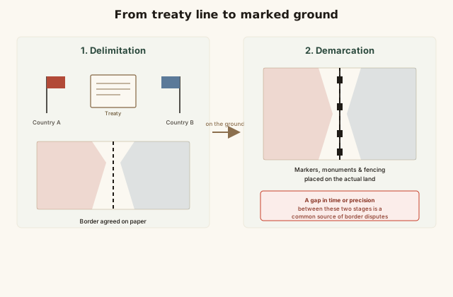
From treaty line to marked ground: delimitation vs. demarcation
The diagram highlights the gap between the legal line (delimitation) and the physical line (demarcation) as the place where most modern border disputes actually originate — two countries can agree on a treaty's wording decades ago and still disagree today about exactly where that line falls once someone tries to survey it precisely on the ground, especially across remote or difficult terrain that was never fully marked.
Common mistakes
Common Mistakes
✕
Assuming all international borders follow a natural feature like a river or mountain range.
→ Many major borders, including large stretches of the US–Canada and US–Mexico borders and most of the border lines across Africa, are geometric — straight lines or lines of latitude/longitude with no natural feature at all.
✕
Treating 'delimitation' and 'demarcation' as the same step.
→ Delimitation is the legal/diplomatic agreement on where a line runs; demarcation is physically marking it. A border can be fully delimited by treaty for decades without ever being completely demarcated on the ground.
✕
Assuming a border drawn along a river stays in exactly the same place forever.
→ Rivers migrate over time through erosion and sediment deposit. International law generally moves a river border with gradual changes (accretion) but keeps it fixed through sudden channel jumps (avulsion) — which is why many modern treaties fix river borders to permanent coordinates instead.
Common misconception
“Borders are always drawn along natural features like rivers or mountains.”
Natural features are common but far from universal. Many of the world's longest and most stable borders — including large sections of the US–Canada border along the 49th parallel, the 38th parallel historically associated with the Korean border region, and the vast majority of national boundaries across Africa — are geometric lines with no underlying natural feature at all. What actually makes a border legitimate and enforceable is legal recognition through delimitation (agreement) and, ideally, demarcation (physical marking) — not whether a river or mountain happens to run along it.
Quick check
Which statement correctly describes what actually makes an international border legally valid?
What to do next
What to do next
Look at a world map and try to spot at least three geometric (straight-line) borders and three natural (river or mountain) borders — both types are more common than most people expect.
Next time a border dispute appears in the news, check whether the disagreement is about delimitation (where the line should legally run) or demarcation (where it's physically marked) — they're different problems with different resolutions.
Read the entry on Territories, Dependencies & Disputed Regions to see how unresolved or contested borders connect to broader questions of sovereignty.
Read the entry on Landlocked Countries to see how a country's border shape — not just its length — determines whether it has ocean access at all.
FAQ
FAQ
Related terms
Related terms
Border
A legally recognized line separating the territory of one sovereign state from another (also called a boundary).
Delimitation
The process of defining a border's precise location in writing or on a map, usually through a treaty between the countries involved.
Demarcation
The process of physically marking a delimited border on the ground, using markers, fences, or survey monuments.
Natural border
A border that follows a physical geographic feature, such as a river, mountain ridge, or coastline.
Geometric border
A border drawn as a straight line or along a fixed line of latitude/longitude, without reference to natural or cultural features.
Superimposed border
A border drawn by an outside colonial or imperial power over existing ethnic, cultural, or linguistic territory, often without regard to those pre-existing boundaries.
 KnowThis