Agriculture & Geography: Why Crops Grow Where They Grow
Crops grow where a region's temperature, rainfall, growing-season length, and soil match that plant's specific biological requirements — which is why global food maps follow climate belts, not political borders.
Reading time
— 5 min
Updated
— Aug 16, 2026
Fact-reviewed
— Aug 16, 2026
Key Takeaways
Key Takeaways
1Every crop has a specific temperature range, water requirement, and growing-season length it needs to mature — a region's climate either meets those requirements or it doesn't, regardless of farming skill.
2Elevation can substitute for latitude — coffee grows near the equator only because mountain elevation cools the air by roughly 6.5°C per 1,000 meters, mimicking a cooler climate.
3Fertile 'breadbasket' regions like the U.S. Midwest and Ukraine share a specific soil type — wind-deposited loess — on top of favorable temperate climate, which is why both became major grain-producing belts independently.
The concept
Crops aren't grown wherever people happen to want them — they're grown where the climate and soil actually let them thrive. Rice needs standing water and warm, humid conditions, so it's concentrated in monsoon Asia's flooded lowlands. Wheat prefers a temperate climate with moderate rainfall, so it dominates the Great Plains of North America and the plains of Ukraine and Russia. Coffee needs stable, mild temperatures without frost, so it's grown at higher elevations in tropical countries near the equator, not at sea level where it would be too hot. Match the plant's needs to the map, and the world's crop belts stop looking random.
Temperature, water, and soil explain most of the map — but the clearest way to see how tightly they constrain a crop is to look at what happens when just one of those three factors is missing.
Quick check
Rice is grown almost exclusively in warm, humid regions with standing water, while wheat dominates cooler, drier temperate plains. What best explains this split?
Worked examples
Example 1: Why wheat dominates temperate plains (baseline case)
Wheat needs a growing season of roughly 90 to 120 days, moderate rainfall (too much encourages fungal disease and lodging, too little starves the plant), and a temperate climate without extreme heat during grain-fill. The Great Plains of the U.S. and Canada, the plains of Ukraine and southern Russia, and northern India's Indo-Gangetic plain all independently satisfy this combination — flat, arable land with a cool-but-not-frigid climate and rainfall in the right range — which is exactly why these unrelated regions all became major wheat-producing belts without needing to share a border, a government, or a common history.
Example 2: Coffee grown at elevation near the equator (edge case / variation)
Coffee, particularly arabica, needs stable, mild temperatures roughly between 15°C and 24°C with no frost — conditions that don't naturally exist at sea level near the equator, where it's simply too hot and humid year-round. Instead, the world's major coffee-growing regions — the Ethiopian highlands, Colombia's Andean slopes, Kenya's highland plateaus — sit at elevations typically between 600 and 2,000 meters. Because temperature drops roughly 6.5°C per 1,000 meters of elevation gained, these equatorial highlands create an artificial temperate microclimate close to the equator: warm days, cool nights, and no frost, all within a few hundred kilometers of latitude 0°. Elevation is functioning as a substitute for latitude — the same trick that lets tropical-latitude countries grow a crop that would otherwise need to be grown much farther from the equator.
Quick check
Coffee is grown at high elevation in countries close to the equator, rather than at sea level in the same countries. What makes this possible?
Example 3: Estimating a wheat harvest from field area and yield (real-world / applied case)
A farmer with 40 hectares of land in a temperate wheat belt, achieving a global-average yield of roughly 3.5 tons per hectare (a figure tracked by the FAO across major wheat-producing countries), would expect a harvest of about 40 × 3.5 = 140 tons of wheat for the season — assuming that season's rainfall and temperature stayed within wheat's normal tolerances. This is the same basic area-times-yield math used at every scale, from a single farm to national agricultural production statistics, and it's exactly why a bad growing season (drought, an early frost, excess rain at harvest) shows up directly as a lower per-hectare yield figure in that year's national output.
How it works (visual)
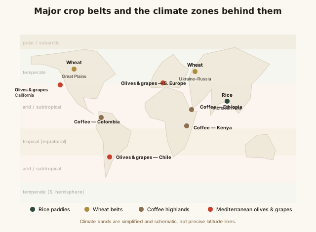
World map: major crop belts overlaid on climate zones
Notice how each crop belt sits inside a specific climate band rather than spreading evenly across the map — rice belts track the humid tropical and subtropical monsoon zone almost exactly, wheat belts track the temperate zone's drier interior plains, and coffee belts sit as small highland "islands" of cooler climate embedded inside otherwise-tropical countries. The crop map is really a climate map wearing a different label.
Common mistakes
Common Mistakes
✕
Assuming any crop can be grown anywhere with enough fertilizer or irrigation.
→ Fertilizer and irrigation can compensate for some limits, but growing-season length, minimum temperature, and frost risk are hard biological constraints that inputs alone can't overcome.
✕
Assuming latitude alone determines what crops a region can grow.
→ Elevation can shift a region's effective climate dramatically — equatorial highlands can be cooler than temperate lowlands much farther from the equator.
✕
Treating 'breadbasket' regions as historical accidents rather than climate-driven.
→ Regions like the U.S. Midwest and Ukraine became grain belts because they independently share a specific combination of temperate climate and fertile loess soil, not because of shared history or policy.
Common misconception
“With enough fertilizer and modern technology, any crop can be grown successfully in any climate.”
Fertilizer, irrigation, and greenhouses can offset some limitations — a poor soil or a dry season, for instance — but they cannot substitute for a growing season that's simply too short, or a climate with hard frost when a crop needs none. Full-season tropical rice paddies can't be replicated in a subarctic climate with a two-month frost-free window regardless of input intensity, and many crops are photoperiod-sensitive, meaning they flower only once day length crosses a specific threshold that a greenhouse light schedule has to deliberately replicate. Climate sets a real ceiling; technology can push against it, but it doesn't remove it.
Quick check
Why can't advanced irrigation and fertilizer alone make full-season tropical rice paddies viable in a region with a short, frost-heavy growing season?
Try it yourself
Estimated harvest: field area × yield per hectare
Estimated total harvest (tons)140
What to do next
What to do next
Try the calculator above with your region's typical crop yield to see how field size translates into total harvest tonnage.
Next time you see a coffee bag labeled with an origin and elevation (e.g. '1,800m'), connect that number to the highland tropics effect keeping the growing region cool enough.
Look up your own region's growing season length and compare it to a crop you'd like to grow — it's the single fastest way to check basic feasibility.
Read the related entry on Climate Zones Explained to see the full climate-band map that crop belts are built on top of.
FAQ
FAQ
Related terms
Related terms
Growing season
The period each year when temperature and daylight conditions are suitable for a crop to grow, typically measured between the last frost of spring and first frost of fall.
Growing degree days
A running total of daily heat accumulated above a crop's minimum growth temperature, used to predict when a crop will be ready to harvest.
Loess
A fine, wind-deposited soil, often highly fertile, that forms thick, productive layers in regions like the U.S. Midwest and Ukraine.
Highland tropics effect
The pattern where elevation cools tropical latitudes enough to support crops (like coffee) that would otherwise need a temperate climate, since temperature drops roughly 6.5°C for every 1,000 meters of elevation gained.
Photoperiodism
A plant's biological response to day length, which triggers flowering or other growth stages in many crops at specific times of year.
 KnowThis