 KnowThis
Key Takeaways
Key Takeaways
- 1Mount Everest's summit (8,849 m) and the Mariana Trench's Challenger Deep (about 10,935 m below sea level) together span nearly 19,800 meters of vertical relief on Earth's surface.
- 2'Highest point' isn't a single fixed idea — Everest is highest above sea level, but Ecuador's Chimborazo is farthest from Earth's center, because Earth bulges at the equator.
- 3Extreme temperature records are formally certified by the World Meteorological Organization, and old records do get overturned — Libya's long-standing 1922 heat record was officially invalidated in 2012 after investigation.
The concept
That last point is worth sitting with: even a planet's "biggest" numbers are estimates that get revised as measurement improves. The clearest way to see how much these different kinds of "extreme" actually differ is to run the numbers side by side.
Mount Everest's summit sits at 8,849 meters above sea level. The Mariana Trench's Challenger Deep sits at roughly 10,935 meters below sea level. Roughly how much total vertical relief separates these two points?
Worked examples
Example 1: Earth's total vertical relief, Everest to Challenger Deep (baseline case)
Example 2: Why Chimborazo, not Everest, is farthest from Earth's center (edge case / variation)
Chimborazo in Ecuador is roughly 2,500 meters lower in elevation than Mount Everest, yet its summit is farther from Earth's exact center. What explains this?
Example 3: How temperature extremes get certified — and overturned (real-world / applied case)
The World Meteorological Organization maintains an official archive of world weather extremes and periodically re-investigates disputed or aging records using modern forensic meteorology — reviewing original station logs, instrument calibration history, and site conditions. This process is exactly what overturned the 1922 El Azizia, Libya reading of 57.8°C in 2012, after a multi-year investigation found the equipment, observer training, and site conditions all suspect; Death Valley's Furnace Creek station reading of 56.7°C from July 10, 1913 became the recognized official world record instead. On the cold end, Vostok Station, Antarctica recorded a direct surface measurement of -89.2°C in 1983 (still the lowest reliably measured surface air temperature by a weather station), while satellite-based estimates have identified even colder surface skin temperatures near -93.2°C over the East Antarctic Plateau — a genuinely different measurement method that WMO tracks as a separate satellite-based record rather than merging it with the ground-station one.
Why did the WMO officially remove Libya's 1922 record of 57.8°C as the world's hottest recorded temperature in 2012, nearly 90 years after it was first recorded?
How it works (visual)
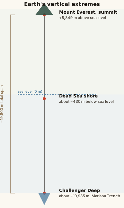
Notice how much closer to sea level most familiar landscapes sit compared to these true extremes — the Dead Sea's shore, the lowest exposed dry land on Earth, is less than half a kilometer below sea level, while Challenger Deep is more than 20 times farther from sea level in the opposite direction. The scale is dominated by ocean depth, not land elevation — Earth's deepest point is more than 2,000 meters deeper than its highest point is tall.
Common mistakes
Common Mistakes
Assuming Mount Everest is the point on Earth farthest from the planet's center.
→ That distinction belongs to Chimborazo in Ecuador, because Earth's equatorial bulge makes points near the equator farther from Earth's center than higher-elevation points at other latitudes, like Everest at 28°N.
Treating 'deepest ocean point' and 'lowest point on Earth' as the same thing.
→ The Dead Sea shore (about -430 m) is the lowest point on exposed dry land; Challenger Deep (about -10,935 m) is the deepest point in the ocean — they're not comparable categories, since one is land and one is seafloor.
Treating a long-standing weather record as permanently settled just because it's old and widely cited.
→ Records are periodically re-investigated by the WMO using modern forensic methods — Libya's 1922 heat record stood for 90 years before being formally overturned in 2012.
Common misconception
“The highest point above sea level on Earth is automatically the point physically farthest from the center of the planet.”
Elevation above sea level and distance from Earth's center are measured from two different reference points and can disagree. Mount Everest is highest above sea level at 8,849 meters, but Earth is an oblate spheroid — flattened at the poles, bulging at the equator by roughly 21 kilometers of extra radius. Ecuador's Chimborazo, at only about 6,263 meters of elevation, sits near enough to the equator that its summit ends up roughly 2.1 kilometers farther from Earth's exact center than Everest's summit. Both facts are simultaneously true: Everest is the highest above sea level, Chimborazo is the farthest from Earth's center. Neither claim contradicts the other — they're just answering different questions.
A textbook claims 'Mount Everest is the point on Earth farthest from the planet's center.' Is this statement accurate?
Try it yourself
What to do next
What to do next
- Try the calculator above with the Dead Sea shore (-430) and Everest's summit (8,849) to see the more everyday-scale relief most travelers actually experience.
- Next time a record temperature is reported in the news, check whether it's a ground-station measurement or a satellite estimate — they're tracked separately and aren't directly comparable.
- Look up your own region's highest and lowest points and see how they compare in scale to the Everest-to-Challenger-Deep relief above.
- Read the related entry on Mountains & Mountain Ranges for more on how elevation itself is surveyed and re-measured over time.